Dog Mountain (D) - Cook, WA 5.16.18

As we lay snuggled in our warm bed my phone began to vibrate and the song “Good Life” by One Republic filled the room. One of my favorite songs was not as welcoming to my ears at 5:30am as I had imagined the night before when setting the alarm. The night prior, Alexis and I read through our hiking books as we delighted in the thought of hiking Dog Mountain, a feat Alexis has wanted to accomplish for nearly 10 years, but for some reason has evaded her. Everywhere I read stated May as being the time of year to hike it, because the wildflowers at the summit are in full bloom. We poured over images, paragraphs and thoughts of Dog Mountain. The expectations and excitement were high as we said our good nights. However, we hit snooze for 30 minutes and slowly rose a little while later.
We checked the weather, it was predicted to be a low of 51 and a high of 70 degrees which would make for an enjoyable day of hiking with blue skies. We grabbed our bags, jump in the car and hit the road. It’s Wednesday and undoubtedly there was a little bit of traffic through the city as we drove through to Cascade Locks. Our first marker on the trip was to cross the Bridge of the Gods. If you google “Bridge of the Gods”, you will find various stories that describe how it attained its name. We both agreed that the best version is the Native American legend told by the Klickitat Tribe. Gathering information from several resources the legend, as I can tell, is that a Great God built a stone bridge for the tribe to cross the Columbia River. Around the same time his three sons Multnomah, Wy’east and Klickitat settled along the Columbia river. All was peaceful until Klickitat and Wy’east both feel in love with Loo-Wit, the guardian of the bridge. She flirted with both brothers, but it is said that she truly loved Klickitat. The brothers soon were caught in such a love rivalry that they began destroying villages and forests. The Great God was so furious with his sons that he shook the earth violently and the bridge crumbled into the Columbia River Gorge creating the Cascade Rapids. For punishment he struck down each of the lovers and transformed them into majestic mountains where they fell. Wy’east, with his head lifted with pride, is known as Mt. Hood. Klickitat, bending his head viewing his love in sorrow remains Mt as Mount Adams and the beautiful maiden, Loo-wit is St. Helens. Today a two-lane steel-truss bridge passes over the Cascade Locks of the Columbia River. Slowly, we drive over it, taking in the beauty and the local legend of the Klickitat Tribe.
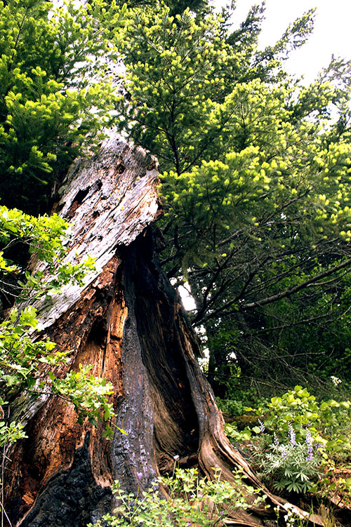
Pulling off the bridge, our GPS tells us to turn right. Heading North for a while we find Bergen Street and think we are close to hitting the trail head. We turn off the pavement and start down a gravel road. Dodging massive pot holes, we are excited at the prospects of starting the huge trek up Dog Mountain. However, we come to a stop at the entrance of a private gate to someone’s house where it is very clear you do not want to go past this point. We reverse on the narrow path that requires me to pull up the side of the mountain ever so slightly and attempt to turn around. We keep trying to reroute, but our phones have no service. At this point we make our way out of the forest and back to the main road. By then, phone service is restored, and highlighted on our map is our true destination about 2 miles up the road. We take a left and continue East to the main trail head.
As we pull into the parking lot, we scan the scene and see people geared up. This hike is rated strenuous and suddenly I feel anxious. Are we truly prepared for this hike? We are each dressed in running pants to the knee, a t-shirt, a light sweatshirt and a vest. It seemed everyone in the parking lot was ready for much colder weather and rain. Feeling uneasy, I get out of the car and sense a cold, wet wind hit me as we walk to the trail head for information. It’s freezing, and we didn’t pack any extra gear today. We grab a payment envelope and nervously walk back to the car. I fill out all the information (date in, expected date out, time, etc.), stuff money into it and seal it up. For a moment I ponder the thought that someone checks this to make sure whoever goes in has come out. Apprehensively I look at Alexis to ask her if she is ready - I know we aren’t. We sit there for a few more minutes trying to soak in the last bit of warmth as we watch four older women pile out of a car nearby. We find solace in the fact that one is wearing shorts and similar attire on top. I lean over kiss Alexis and say, “let’s go!”.

We drop the envelope in the random rusted box at the trailhead and snap a quick “before” selfie. The faded sign barely shows the flowers that will be found on the hike, but the quote by Ralph Waldo Emerson jumps off the sign and emanates with me: “The earth laughs in flowers”. A huge smile washes over me as I feel a renewed sense of vigor and we head up the first part of the trail. That energy lasts all but 30 feet as my quads start to burn, my breathing feels heavy, and I am no longer wondering what “strenuous” means to the author of the book. We take a short break, and as we turn to keep moving notice a fit older gentleman with a white fluffy beard and muscular legs running down the mountain towards us. He turns the corner and fades out of site. Alexis looks at me and laughs “Fit Santa just passed us”. Chuckling I agree that indeed Fit Santa just passed us.

As we walk we start setting goals ahead of us as stopping points. “You see that tree up ahead? Let’s take a break there”. Somehow on a trail completely lined with trees we both knew exactly what tree either of us was referencing. We were about 30 minutes into the hike when I turned to Alexis and jokingly said “I just figured out why they call it Dog Mountain, because you pant like a dog trying to make the trek.”


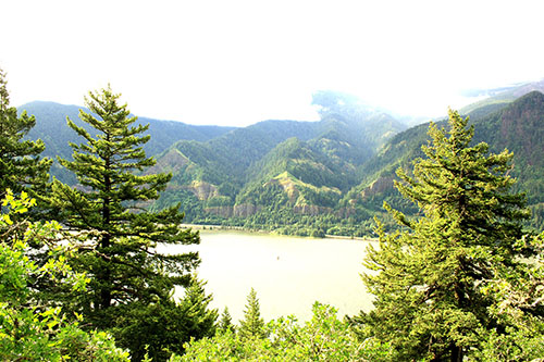
This hike is well known for its difficulty due to the amount of elevation gain. Already in half mile we gained 662 ft in elevation and my body can feel it. We come to a sign that points to two different directions: difficult or more difficult. Knowing that we weren’t as fit as we should be for this hike we without hesitation veered towards the difficult route. Along this route the sun peaked through the trees and at each switch-back we were able to catch a glimpse of the Columbia River below. Hiking this side of the mountain allowed us to be blocked from the wind. Our bodies were warmed by the sun, giving us the confidence that we had in fact appropriately dressed. Around 1.6 miles at an elevation of 1621 ft, we came to a beautiful opening that was littered with yellow wild flowers on our left and a gorgeous view to our right. We went out to a small bench, sipped on water and had a quick snack. As I sat there I could see the rush of the highway on the Oregon side of the Columbia River and heard nippy little dogs barking. Life was happening all around us and yet here we were, on a Wednesday, taking in the beauty of this huge mountain and the rest of the Columbia River Gorge. We took the obligatory selfie, I snapped some pictures, and we decided to forge ahead.

As we moved up the next portion of the trail the temperature started to decrease, and the wind picked up. After sweating on the first portion of the hike the falling temperature was welcomed. The winds made for an eerie climb as they pushed the clouds Eastward rapidly engulfing the mountain. At this point the four older women from the parking lot, whom we had decided were in their mid-sixties and in a hiking group together, had surpassed us and several times encouraged us to pass. Sheepishly, the has been athletes that we are, told them they were setting a good pace for us.

We came to the final fork in the trail where we had to decide to either advance and climb the final 1.4 miles up hill to the summit, or head back down to complete the loop. Without a question in our minds we continued forward up the steepest part of the trail with an elevation gain of almost 300ft in less than a half mile. Hikers coming down said that the top was worth it and so we kept moving. Before long we came to an opening where both sides of the trail were covered in yellow flowers. While the site was beyond spectacular the weather had drastically shifted. The wind was racing over the side of the mountain, the fog was dense, and the temperature significantly dropped. We came to what is known as “Puppy Point”, elevation 2,543ft, and 0.9 miles to the summit. The older group of women were pulling extra gear out of their bags and debating whether to continue. I overheard one of them say “you can get hypothermia if you’re not careful”. I look up the trail to the summit with the visibility only about 30 feet ahead of us, then look back over to Alexis. We again realize the downfall of not packing adequately. We edge over to a small rock slightly away from the ripping wind to try to decide our next move. The four women decide they are going to go for it, while three other women who had now joined us at the point decided it was too dangerous. We both agreed that we just should head back down and try again next year. As we turn to make the descent, two of the four women group had already turned back. I took a moment to video the sheer power of the wind and lack of visibility and noticed the other two women coming back down the mountain, not having made it further than 50 ft. before turning around.

We descend back to the covered trail and try to move quickly to warm up our bodies. In no time we are back at the point where the trail makes the loop. We decide to turn right and head down on the second half of the loop instead of going back the way we came. This side of the trail seemed less strenuous (even though it was deemed more difficult) and the scenery was lacking. It was nothing but woods the entire trip down whereas the other side had multiple pockets that boasted beautiful views of the Columbia River and some wildflowers. The best moment on this side of the trail was coming across an older man who was making his way up the trail. As we approached him we were worried if he was ok. He asked me if we had seen him in the parking lot. I replied I didn’t think so because we left hours ago. With a smile on his face he looked down at his shaking hand to see what time it was and replied that he left around 8:30am. I paused, realized that he probably did see me and took in the moment. Here was an older gentleman dressed in hiking boots, pants, button down shirt and a bright orange hat who was slowly, but defiantly making his way up Dog Mountain, one of the most strenuous hikes in the Northwest. He tells us that he has done this hike for 42 years and he has seen so much of the scenery change. After a few more minutes of conversing we part ways. He turns, laughs, and says “Enjoy getting back to your car. It’s like a long-lost love affair!”.

As we make it the rest away we move quickly and with every step I grimace. The years as a high-level athlete have destroyed my knees and the pain is present on the descent. Alexis keeps turning around to check in on me. With a thin smile, which I know she reads through, I let her know to keep moving. Sure, enough we make it to the trail head. Our bodies ache, but we just finished an amazing hike! We took our final selfie of the day by the Dog Mountain sign.
We sunk into the car, removed our shoes and put on flip flops. The trailhead is packed and the parking lot full. We note the numerous people we passed on the way down compared almost a complete ascent of solitude. If you interested in this hike, we recommend starting early in the day. Even though we didn’t make it to the summit, we believe the hike is worth it.
As we pulled out of the parking lot we discussed where to go for lunch. Our reward after a big hike; great food and a drink. Alexis described a place to me which I could not really truly appreciate until we arrived. Pulling off I-84 at exit 16 we made our way to McMenamins Edgefield and parked. The air was brisk and there was a cloud covering, but we still wanted to sit outside. We found our way to the patio, outside the pub, where wood fires were burning amongst the scattered metal wire tables. Ash and smoke danced through the sky as we made our way to the table next to the largest fire pit. Having passed a sign on the side of the road that advertised Wild Fresh Salmon, I now craved it. I ordered the Salmon sandwich while Alexis ordered a salad. Sipping my Moscow Mule, I took in the atmosphere. There was an old building next to the patio that had faded signs designating it the Pub; umbrellas and metal wired tables were randomly covering the patio with a few groups of people filling them in. The area was surrounded by green shrubbery and random metal pipe art. This is exactly my type of place to relax after a strenuous hike. No pressure or hustle of the outside world affecting the moment.

After a delicious lunch we walked the grounds viewing the amphitheater, a small pub in a tiny house, the vineyard, the gift store and lastly the glass blowing studio. We spent the most time here as we watched two experts work to create this beautiful glass jar for olive oil. I clicked away on my camera, hoping that I could grab at least one decent shot as the glassblowers quickly moved from the fire to their seat. The two moved with an unspoken grace that let us know this wasn’t their first dance. When we were about to leave, a glass hummingbird feeder caught our attention. We purchased it not only for its beauty, but as a reminder of an amazing day.

We highly recommend you check out McMenamins Edgefield and don’t leave there without stopping by The Gorge Glashaus hot glass studio. The owner Peter Neff was the artist we had the pleasure of watching, but they have several artists that he works with throughout the week.
Pulling out of the parking lot we got back onto I-84. Cruising home we sang along to the music streaming from the radio and felt elated about our awesome day. Sitting back and I realize still till this day Alexis, and now I, haven’t truly completed Dog Mountain. As we set our sights ahead on our weekend trip I know we will one day summit this peak. Until next year Dog Mountain!


Difficulty - Strenuous
Distance - 6.9 miles
Route Type - Out and Back
Elevation Gain - 2,700 feet
Best Time - Early Morning - May
